 Filter: Categories of Wisconsin Historical Images
Filter: FORMAT_DIMENSIONS of 28 x 17 inches
Filter: Categories of Wisconsin Historical Images
Filter: FORMAT_DIMENSIONS of 28 x 17 inches
| Date: | 1896 |
|---|---|
| Description: | Section 1 of 12, this bicycle road map features Wisconsin bicycle routes in the counties of Dane, Jefferson, Waukesha, Milwaukee, Green, Rock, Walworth, Ra... |

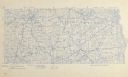
| Date: | 1896 |
|---|---|
| Description: | Section 2 of 12, this bicycle road map features Wisconsin bicycle routes in the counties of Marquette, Green Lake, Columbia, Fond Du Lac, Dodge, Washington... |

| Date: | 1896 |
|---|---|
| Description: | Section 3 of 12, this bicycle road map features Wisconsin bicycle routes in the counties of Winnebago, Calumet, Manitowoc, Outagamie, Brown, Kewaunee, and ... |

| Date: | 1899 |
|---|---|
| Description: | A map of the west part of the city of Madison, including University Heights and the Capitol Square. |

| Date: | 1899 |
|---|---|
| Description: | A map of the east part of the city of Madison, including a portion of the isthmus. |
If you didn't find the material you searched for, our Library Reference Staff can help.
Call our reference desk at 608-264-6535 or email us at: